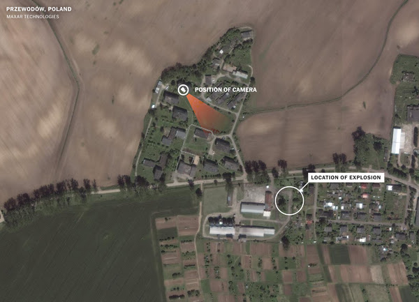
Denys Davydov, the Ukrainian airline pilot who posts regularly on YouTube, and a number of other interested observers online, have pointed out that if you combine the latitude of Kyiv, Ukraine [50.4501N] with the longitude of Lviv, Ukraine [24.031E] you get a place in Poland, very near Przewodów [50.47099N, 23.93432E] where a missile of disputed origins is said to have killed two farmers. Which is a very big coincidence!!!
Giving that a closer look, and using this photo published by the New York Times of the attack site:
To further test this theory, I'm trying to find likely targets along 50.47453N in Kyiv, and along 23.92314E in Lviv, and here I have to ask for help because I can't read Ukrainian. So, finding likely targets is difficult.
We know that Russia has been focused knocking out Ukraine's electric power grid. In furtherance on his genocidal war, Putin is attempting plunge Ukraine into darkness ahead of the coming winter. Most of Tuesday's targets were along those lines, and so a likely place to look for these "missed opportunities."
I have determine that Kyyivsʹka Rayonna Elektrostantsiya, Kyiv's Hydroelectric power plant is located at 50.47984N, 30.51401E. That is only 1,818.05 ft (554.14 m) north of 50.47453N, the latitude of the Polish strike.
That may not have been the exact target, but looking at the area around there—the plant is located on the Dnieper River—we find what looks to me what Maverick would call a "target rich environment" for anyone going after Kyiv electrical infrastructure. For example at exactly 50.474672N and ~30.52E we see what appears to be an industrial area along Elektrykiv St. [Electric St.]
Now, it's getting quite late, and given the urgency of the subject matter, I want to get this out tonight, before I go to bed, and before I do a more extensive search for likely targets in Lviv along 23.92314E. For that I need help from those that know Lviv, or can read Ukrainian labels on a map, but I did note this industrial area at ~49.8280N, 23.923390E:
So, as we can see, not only does the latitude of the missile strike in Poland match that for Kyiv, it most likely lines up with specific electrical grid targets in Kyiv. Ditto for the missile strike's longitude and, at a minimum, industrial areas in Lviv.
There's an old cop saying—never believe in coincidences. Now, the Biden-Poland-NATO explanation for the strike is a Ukrainian air defense missile inadvertently ended up hitting a target in Poland. But a ground-to-air S-300 missile is aimed at a moving target, not fixed coordinates. A ground-to-ground S-300 would be targeted using fixed coordinates. So, what are the chances that a Ukrainian air defense missile gone wrong would just happen to land at latitude that fits likely targets in Kyiv and a longitude that fits possible targets in Lviv? I hope to have updates on possible Lviv targets later today.
If my latest "conspiracy theory" holds water, and I think it does, it means Zelenskyy is speaking truth to power when he contradicts Biden & NATO, and insists it wan't a Ukrainian missile. It also raises the question of why Biden is trying to let Putin off the hook by claiming it was a Ukrainian missile.
More on that later,
Clay Claiborne
17 November 2022
UPDATED 22:20
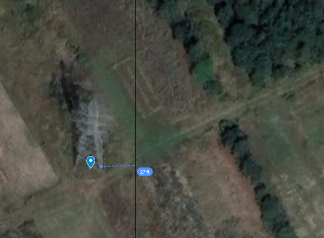
Using pictures available from a number of sources, I have updated the explosion coordinates in Poland to 50.47453N, 23.92314E, a change of 75 ft.
 |
| So far, my best potential missed target in the Lviv area is this major high voltage tower. It is less than 27 ft. from the 23.92314E longitude line. Are they taking out HV towers with S-300s? |
More on the S-300 Missile systems:
I am writing this on the same day that, after 8 years, a Dutch court has found Russia responsible for the deaths of 298 people when it shot down flight MH17. They also found that Russia runs Donbas. Thanks, we all knew that.
Anyway, on the S-300. It was originally designed as a surface-to-air missile system in 1975, and first put into service in 1979. So, not exactly their newest system, which is the S-400 (2007). Of course, there have been many improvements over the years. Wikipedia lists 25 different models, with various ranges and other capabilities. But all those models have been exclusively ground-to-air systems.
As to targeting and guidance Wikipedia says: "The system is fully automated, though manual observation and operation are also possible." Air defense weapons shoot at a moving target. Fixed coordinates are useless. If it's not a human pointing and shooting, some sort of automation is absolutely necessary. As to its use in Russia's war on Ukraine, Wikipedia also says:
On 8 July, the governor of the Mykolaiv Oblast, Vitaly Kim, claimed that Russia has been using S-300 missiles in a land attack role by fitting them with GPS guidance and that some 12 missiles were fired this way.[102] On 30 September, The Wall Street Journal reported that 16 Russian S-300 missiles configured for ground attack struck near Zaporizhzhia, killing at least 30 civilians and wounding 50 others.[6] Debris from S-300 missiles was found after having struck buildings in Kharkiv on 8 October.[5] Analysts from McKenzie Intelligence Services and the Center for Strategic and International Studies said that these missiles were likely from Russian systems repurposed for ground attack due to dwindling stock of more precise dedicated anti-surface missiles.[5]Since
After hitting Ukraine's power infrastructure with 100 missiles on Tuesday, and Poland was hit as well, Russia observed an operational pause yesterday. Was it to figure out what went wrong, or to see how NATO would respond? In any case, they were back at it again today, adding gas storage facilities to the list with electrical infrastructure. This means we should be looking for gas storage facilities as well as electrical stuff along 50.47453N in Kyiv and , 23.92314E in Lviv to see if it was a Russian targeting error.
I think the best publicly available evidence points to a Russian screw up and a NATO cover up—and we all know why. But, so far, Zelenskyy is refusing to go along with the program.
More, later...
UPDATE 18 Nov 2022:
Reporting on Russia's attacks on Ukrainian energy infrastructure, the Atlantic Council wrote:
As to what type of ground targets a S-300 missile might be used on, the UK MOD thinks one was used to attack a convoy in Zaporizhzhia in October.
Since early October, Russia has launched hundreds of missiles and kamikaze drones at key infrastructure targets including Ukrainian power plants, large substations which facilitate the flow of electricity to consumers, high-voltage transmission lines, and distribution lines across the country.Vox has also reported "Russia is also targeting things like transmission lines that carry electricity, or transformers that transfer electricity from one circuity to another." The Washington Post also reported that previously "transmission lines came under attack." So, it's pretty clear that this lowly HV transmission tower may well have been a target.
As to what type of ground targets a S-300 missile might be used on, the UK MOD thinks one was used to attack a convoy in Zaporizhzhia in October.
I have found what appears to be a major electrical substation in Kyiv at 50.47453N, 30.41139E. This is exactly on the same longitude as the missile strike in Poland. Being it is Kyiv, I was even able to "walk" around, and "take" a few pictures with Google Street View.
 |
| The whole yard is fenced off, and surrounded by metal sheds, but you can see the tops of HV towers. |
 |
| This shot, through what looks like a cheap motel, or storage yard, gives us the best look I found of what's inside the perimeter. |
 |
| The white box shows what appears to be the electrical yard.As you can see the yard is quite large. It measures 2/3 mile around the perimeter. The red line is the 50.47453 N Line. |
Could this have been the "missed opportunity" of a missile that was suppose to be headed to Kyiv?
More, later
My Polish Missile Strike Map:
This shows why Biden could quickly say it didn't come from Russia, once the missile had been identified as an S-300. The S-300 has a maximum range of 195 km. The circle on the map below shows a circle with a radius of 200 km. If the missile wasn't fired from Ukraine, Belarus is the only beligerent that it could have been launched from. Of course, that might be all the more reason to cover it up. If it proved to be a Russian missile fire from Belarus, then we are truly on our way to another world war.


Bellingcat published The Remote Control Killers Behind Russia’s Cruise Missile Strikes on Ukraine 3 wks. ago. It goes into some depth into those who program Russian missiles and most likely made the mistake. https://www.bellingcat.com/news/uk-and-europe/2022/10/24/the-remote-control-killers-behind-russias-cruise-missile-strikes-on-ukraine/
ReplyDeleteCo-ordinates of Kyiv bridge on the Dnipro: 50.47444 N, 30.5265 E
ReplyDeleteCo-ordinates of Lviv government building: 49.825 N, 29.9214 E
If Russians trying to hit those two sites mixed up the co-ordinates, they hit
Impact site in Poland: 50.47444 N, 29.9214 E
Your information appears to be incorrect. Google Maps says 50.47444N, 29.9214E is Makarivs'kyi district, Kyiv Oblast, Ukraine
Deletehttps://www.google.com/maps/place/50%C2%B028'28.0%22N+29%C2%B055'17.0%22E/@50.4744434,29.9192113,17z/data=!3m1!4b1!4m4!3m3!8m2!3d50.47444!4d29.9214?hl=en